Showing posts with label Practice Approaches. Show all posts

15 November 2015

Taxiway to the Edge of the World

N430AV - P28R - 2.7 hours

As the weekend approached, a flight instructor friend of mine asked if I'd want to split time in an Arrow to enjoy the nice weather. Not one to pass up an opportunity to fly, but also be able to log time toward the instrument rating requirements, I took him up on it. I had been wanting to get out to Hot Springs (HSP) for quite some time. It's a unique airport, being on top of a mountain, and is actually the highest airport east of the Mississippi River. This spot also causes it to be subject to various wind hazards to challenge you on approach. Today, being a windy day, meant that those challenges would be present for my first visit.

Since my friend is based out of Manassas (HEF), I got a break from Leesburg (JYO), and a refresher on the procedures down there. Apart from having to talk to controllers in the tower, and filing a flight plan, it really isn't too different. After departing, we flew directly out to HSP, and I was able to throw the blinders on to log instrument time. Closer to the field, I flew the ILS approach for practice, beginning with a hold for good measure.

Just before landing, the wind started to play games with my approach path and I ended up pretty low. It wasn't the prettiest final approach, but it got the job done. As soon as we exited, we brought the plane back to the runway to head back home. I have been into some pretty unique airports in my years of flying around, but I was not prepared for what I saw as I rolled up to the hold short line. The taxiway comes right up to a sharp drop off, giving you a pretty spectacular view as you prepare yourself to depart.


Once back in the air, I put the blinders back on to log some more time on the way back home. It was a pretty simple flight, but quite a visually memorable one. Of course, it didn't hurt that I was able to log time toward the simulated instrument, and complex requirements.

Hours:
Pilot in Command Cross Country (PIC XC): 2.7 - 127.1 (of 50)
Actual/Simulated Instrument (Act/Sim): 1.9 - 30.7 (of 40)
Dual Complex: 2.7 - 7.7 (of 10)
Total Time in Aircraft: 2.7 - 195.8 (of 250)

02 July 2015

More Instrument Time - Less Weather

N172DR - C172R - 3.0 hours

My friend James and I have been talking about flying off and on for years. I actually met him when I lived out in Phoenix, which was partially the reason this blog came into existence (trip reports for my family/friends, as I'd intended to get my additional ratings out there back in 2008), and even though we worked at the same flight school, we had never flown together until today. Since we had been talking about flying and my last flight didn't go as planned, I figured we would try it again.

We flew up to Reedsville (RVL) through the use of VORs only. I'd planned on this, but we found that the GPS ended up being INOP when we got to the plane. As I was under the blinders for the flight, I was guided around a few cells all the way up to RVL, shot the LOC Runway 6 approach, flew the missed with one lap around the hold, and then flew the approach again for more practice. To get the cross country time, I touched the wheels down on the runway and then set off towards home.

Adding to this non-GPS challenge was some sort of issue (my guess is vacuum-related) that made my artificial horizon gauge unreliable. It's always an interesting situation when you've developed a good trust in your instruments, and then they start wandering on you. As I was flying the first LOC approach, I noticed that when the gauge shows wings level, I felt like we were turning, and the turn coordinator and directional gyro confirmed this. I never thought I'd get actual partial panel experience, but it was actually neat to see it in a controlled environment.

The route back was by VOR again, and finished with the ILS Runway 17 approach back into Leesburg (JYO). Another 2.7 hours of simulated instrument in the book, so I'll call that a success.


Hours:
Pilot in Command Cross Country (PIC XC): 3.0 - 107.0 (of 50)
Actual/Simulated Instrument (Act/Sim): 2.7 - 22.9 (of 40)

21 June 2015

Fighting Weather

N329ME - C172S - 2.6 hours

As I've been in an endless struggle to accumulate more simulated instrument hours, I plotted out a couple flights that would help me to that end. Given the weather we've been having lately - lower clouds with rain - I figured a route to the south and a route to the north would give me the best chances. The mountains to the west could get dicey if the clouds got too low, the airspace to the east is relatively foreboding, and the north/south option gives me an option to use the opposite direction if we departed and found the weather to be less than desirable in the initial direction (it's summer, and storms are regular).

Of course, that plan of having a backup worked in our favor, as a storm began to develop over Warrenton (HWY), which is where we were headed. Phil pointed this fact out to me since I couldn't see it under the blinders, so I turned back to the north to pick up the Martinsburg VOR (MRB) and continue in that direction to Reedsville (RVL). Unfortunately, weather developed in that direction, too, and cut us off from the airport as we began the instrument approach to the field.

Nope...
After turning back around to head home, I decided to pick up an ILS approach into Hagerstown (HGR) to get a break and use the facilities, and then head back to fly the ILS into Leesburg (JYO).

Despite not accomplishing the goal of flying the approach into RVL, I still picked up 2.4 hours of simulated instrument, so I'm now over half way there.

Hours:
Pilot in Command Cross Country (PIC XC): 2.6 - 104.0 (of 50)
Actual/Simulated Instrument (Act/Sim): 2.4 - 20.2 (of 40)

14 June 2015

Anyone Available for a Ferry Flight? Yep.

N950ME - C172M - 1.4 hours

There are some times during the weekend where you simply find yourself with nothing left to do. Granted, this doesn't happen often for me between my day job forcing a lot of my activities to the weekend, my PMDG job contributing to that, PMDG Flight Ops activities (flying around in a DC-3, obviously, usually takes priority over just about anything else), and various other activities like visiting family and keeping the fridge stocked. To be clear, I have nothing against any of those things (besides maybe my day job), but it does mean that I'm rarely simply sitting there trying to come up with something to do.

Luckily, today was one of those days, and I saw an email go out from the school I got checked out with back in April. They needed a pilot to help chase an aircraft from Manassas (HEF) to Stafford (RMN), in order to bring him back from his ferry flight. I immediately called the school to offer to help out and was told to head down to the field and coordinate with the other pilot.

Once there, we waited out some isolated, typical summer storms and set off to RMN. The weather on the way over was still pretty hazy, and there were still isolated rain showers in spots, which was an interesting experience, and offered some pretty cool sights.


On the way back, the other pilot offered to let me log hood time, both to help me get the time, and to help him log time and not just sit there. We were nearly all the way back to HEF when we decided to see if the controller could give us a practice approach to the field, which actually took us all the way back over RMN. It was extra time, though, and time that I needed, so neither of us complained.


After bringing the plane back in and getting it tied down, we added our entries to the logbooks and then headed home. I, of course, stopped by to say good night to the 3 on the way out.

Hours:
Pilot in Command Cross Country (PIC XC): 0.0 - 101.4 (of 50)
Actual/Simulated Instrument (Act/Sim): 0.7 - 17.8 (of 40)

15 May 2015

Dinner and an Approach

N5165M - C172R - 1.1 hours

Today was primarily a last minute decision to take advantage of nicer weather and fly. This time, the plan was to fly up to get dinner at a restaurant in Hagerstown (HGR) that the DC-3 crew frequents with Phil and his friend Brittany. The flight up to HGR is pretty simple as you don't really have to even turn much if you're departing Runway 35. There is a tower there, though, so there is a little extra radio work. The flight up and back was barely 1.1 hours total, and part of that time was added by flying an approach to Runway 17 at Leesburg (JYO).


Phil, in keeping with his constant challenges (makes him a great safety pilot), "failed" my GPS and had me keep the blinders on until right above minimums. Despite chasing the needles some when I got closer to the airport, I ended up settling on the localizer and glideslope nicely and removed the blinders with the field right ahead. Can't argue with that.

Short flight - short post.

Hours:
Pilot in Command Cross Country (PIC XC): 0.0 - 98.5 (of 50)
Actual/Simulated Instrument (Act/Sim): 0.5 - 17.1 (of 40)

07 March 2015

Practice Approaches

N571DS - DA40 - 2.4 hours

I've been wanting to get some time under the blinders, along with some approaches in recently. With that in mind, I sent a message to Phil to see if he'd be up for sitting right seat while I attempted to follow imaginary lines in the sky by reference to the instruments inside the airplane alone. The route I came up with was Charlottesville (CHO), a hop over the Blue Ridge Mountains and an approach into Shenandoah (SHD), and then a trek back to Leesburg (JYO). Through all of this, the plan was to just string it all together without getting out of the plane. Luckily, that all went as planned.

Departing JYO, we flew to the Casanova VOR (CSN) and followed the V140 airway to just prior to WITTO, where we were cleared to the HOODE intersection and onto the RNAV Z Runway 21 approach at CHO. After briefly setting the wheels down so that I could log the flight as cross country time, we were vectored to OLAJO and onto the RNAV Runway 23 approach. We flew the missed approach toward GABEL, but Potomac vectored us back toward JYO before we got there to avoid wasting time. Closer to JYO, the controller vectored us in for the ILS Runway 17 approach to round out the flight. Luckily, Phil took a few pictures of the flight as having the blinders on makes for boring imagery and flight narratives.

Here is one crossing the ridge between CHO and SHD:


Hours:
Pilot in Command Cross Country (PIC XC): 2.4 - 95.6 (of 50)
Actual/Simulated Instrument (Act/Sim): 1.9 - 16.6 (of 40)

30 December 2013

Freezing and Flying

N172HF - C172S - 1.1 hours


When I went up for my BFR, my intention was to fly down to Raleigh (RDU) for another ice hockey game, but the weather didn’t end up looking too great. In order to make sure a plane was available, I had booked the flight well in advance. I felt bad having reserved the newest plane in the fleet for a flight I wouldn't be taking so I ended up just editing the reservation to push it back by about a week. Luckily, my pilot friend Katelyn wanted to join, so I could continue to get more simulated instrument time. We flew together nearly two years ago, on a quick flight down to Luray (LUA).  Even though she had flown more recently than that flight, it had still been a while so she wanted to go back up and get the feel for it again. That said, we worked it out where I would get simulated instrument time and approaches in between Leesburg (JYO) and Winchester (OKV), and she would get some landings in to get the feel for it again.

I was able to escape work a little early to make the long trek out to JYO (it takes forever now that my office is in DC), but Katelyn ended up getting stuck in traffic. Jokingly, I told her that I would sit there and pass the time taking pictures of myself with the plane. Once I finally got to the plane, however, that joke actually sounded like a good idea since I’m pretty sure this blog now has over 200 photos in it (the videos take that number even higher), and I’m pretty sure I’m in maybe 10 of them. In an effort to make said author less faceless, here’s a picture of me and an ironic statement all in one.

If you're not getting the ironic statement, look at the tail versus my apparel

I was able to get the plane all set up prior to her getting there, which ended up working out, as we departed as night time officially started (for logging it, anyway). As soon as we departed, we went directly to CLADD to fly the ILS Runway 32 approach into OKV. On the way, I pointed out some of the features of the G1000 as we both joked continuously about how it really felt like cheating based on the equipment we learned to fly with. Since she’d flown with Garmin equipment, though, she picked it up pretty quickly.

I flew the approach down near the minimums, but with the flight path vector (FPV) and runway showing up on the Synthetic Vision display, it really felt like I was just flying in a low detail version of Flight Simulator (side note, I was recently part of a Washington Post article on that very topic). I made the first landing since I flew the approach down so low.  After the landing, I took back off, and passed the controls over to Katelyn for a few laps of her own.  Three landings later, I took the controls back to fly the LOC Runway 17 approach into JYO (the glideslope has been out for a while, so it’s LOC only for now).

Compared to the approach I flew at the end of my BFR, this one looked really good. Then again, the approach I flew during my BFR wasn’t aided by Synthetic Vision displays, or a cue that factors in wind drift for you. I seriously feel like I’m cheating using something like that. Don’t get me wrong – I think it’s an awesome tool for the practical environment, but I think I’m going to stick to doing it the hard way for my training. It’ll help me appreciate the G1000 with SVT more, and it’ll keep my skills sharp for all of the fleet.

In the end, it was 1.1 total and 0.7 of that with the blinders on. Not bad since the only major obstacle between me and the instrument rating is all of the simulated instrument time.

Hours:
Pilot in Command Cross Country (PIC XC): 0.0 - 88.2 (of 50)
Actual/Simulated Instrument (Act/Sim): 0.7 - 14.7 (of 40)

30 November 2013

The Hiatus is Over

N172DR - C172R - 1.0 hours

As of today, I’m back in the air and can legally go off on my own, exercising the privileges of a private pilot. I went up this morning with Tim (the instructor who helped me get checked out in the DA40 back in March) to complete my BFR. We were supposed to go up last week, but scheduling got in the way of that flight.

Today’s flight was nice and simple. The wind was calm, and the clouds were pretty high. The only detractors were that I needed to spray the plane down with glycol (de-icing fluid), and add two quarts of oil (ruining my shirt in the process). After all of the ground items were taken care of, we were off.

I’m always surprised by how easily flying comes back to me after long breaks. After clearing the ridge and getting out to the practice area, Tim had me demonstrate slow flight. After that came the rest of the typical PPL maneuvers: power on stalls, power off stalls, steep turns, and engine out procedures. In my never-ending drive to get more instrument time, I also asked if I could throw the blinders on to fly the approach back into Leesburg (JYO). The approach went well, though the glideslope wasn’t providing us an indication. Luckily, the approach is an ILS/LOC approach using cross radials to identify the fixes, so I just put the Frederick VOR (FDK) in the NAV2 spot and identified step down fixes that way. Despite some hunting of the LOC, I ended up on altitude and centerline in the end, which was a nice way to end a flight after a four month absence.

Given the nature of the flight I didn’t end up recording it, or even snapping a picture (got distracted with the glycol and oil before the flight), so this post is atypically light on visuals. The next flight should have more of that. Speaking of the next flight, I need to get my passenger currency back for a flight later this month, so expect another post sooner rather than later.

Hours:
Pilot in Command Cross Country (PIC XC): 0.0 - 86.5 (of 50)
Actual/Simulated Instrument (Act/Sim): 0.3 - 14.0 (of 40)

26 April 2013

More Instrument Time

N172DR - C172R - 2.1 hours

As somewhat of a last minute thing, a coworker of mine asked if I wanted to go flying so he could get his night currency back.  I almost declined, having just gone last weekend, but since Eric is a CFI and I need to continue chipping away at the instrument requirements, I figured it was a good opportunity.

Since I didn't get my Grant County (W99) flight in last weekend, I figured I would fly the approach there, stop through Winchester (OKV), and then head back to Leesburg (JYO).  That would give him three takeoffs and landings, and it would get me a decent amount of simulated instrument time.

Departing to the west, I put the blinders on and picked up the Linden (LDN) VOR, which is the initial approach fix for the LDA/DME-B approach to W99.  Since LDN is pretty far away from W99, it gave Eric plenty of time to ask general flying questions before we concentrated on the actual approach.  Unfortunately, in order to keep the localizer in the NAV1 spot, I had to put LDN in the NAV2 spot which was unlit.  You can see the oscillations in the track as I wasn't as on top of it as I should've been (first going southwest towards LDN, and then I turned too early to the west, away from LDN).  In any case, I made it onto the localizer in the end, which put me right on top of the field.

As you can see on the chart, the airport is surrounded by terrain, so much so that a straight-in approach cannot be made with the necessary safety margins required by the FAA.  For this reason, the LOC is offset 25 degrees from the actual runway heading.  Moreover, this is also why it is a localizer-type directional aid (LDA) approach instead of being a localizer (LOC) approach.

For those who aren't pilots, localizers are normally placed at the far end of a runway and provide lateral guidance to it.  In this case, the localizer has been placed to the left of the runway, on the near side, because of terrain.  Being on the near side means that it is more sensitive, and therefore slightly more difficult to track, when compared to a normal LOC approach at similar distances from the field.  Additionally, because of the offset and the terrain, the minimum altitude you can descend to on the approach is 1540 feet above the elevation of the airport.  Because you're so high, so close in, it is designed as a circling approach, where you wouldn't normally immediately line up with the runway to land (note that the chart only lists "circling" at the bottom, with no "S" - or "straight-in" - minimums); rather, you would spot the airport closer in, circle around the airport to lose altitude, and then to land.  You can see this in the CloudAhoy track below (the knot at the far left of the blue line).  While the concepts of the various approaches are similar, approaches like this offer somewhat of a challenge, when compared to those offering straight-in procedures (which is what you experience on 99% of commercial flights if the weather is poor).

I ended up overflying the field, and passing the controls to Eric so that he could make his landing.  After a quick full stop landing with a taxi back, we departed to the north to avoid terrain.  If you look back at the approach chart, you'll see that there is a valley north of the field to follow until you clear the mountains.  Once above the terrain, I took the controls again with the blinders on to log more instrument time towards OKV.  After Eric had OKV in sight, I passed the controls back to him for a lap around the pattern and a full stop landing.  Since the weather was nicer, a few others were taking advantage of it for night currency as well, so I called traffic with the blinders off while we were in the pattern.

One of the pilots who landed before us decided to stop right next to the taxiway for some reason, but we managed to get by.  After the departure, I put the blinders back on and took us back to JYO.  Once again, Eric called the field in sight, I passed him the controls for the landing, and that was that.  By the way, if anyone wants to see the perfect example of a full stall landing, see this guy.


From all of the questions throughout the flight, it seems I need to dig back through the books to brush up on some of the items I've forgotten over the years.  It was a great flight, though.  He has his night currency back, and I have 1.6 more hours of the instrument requirement (not to mention 1.6 more instrument dual).

Hours:
Pilot in Command Cross Country (PIC XC): 2.1 - 84.1 (of 50)
Actual/Simulated Instrument (Act/Sim): 1.6 - 13.7 (of 40)

21 April 2013

Chipping Away at the Instrument Requirement

N96178 - C172P - 2.3 hours

Initially, there was some talk that I would be flying someone around this weekend, but I never heard back about it.  By the time Saturday came and I saw how nice it was outside, the thought that I should have been flying resurfaced.  Not being able to suppress the thought, I called Phil to see if he would want to be a safety pilot for a few hours.

My initial thought was a quick trip out to Grant County (W99), because it has an interesting approach, and would be an easy flight out and back.  Phil brought up the idea of State College (UNV) again, from the times we've debated doing it in the past, adding that it would be a good spot for dinner.  Unfortunately, the dinner idea didn't work out as well as we had expected, as the restaurant we wanted to go to would have been closed by the time we got there.  Adding to that issue was that the wind at airports to the north and east weren't exactly the best.  While we both noted that I had previously put a plane down on a tiny runway with a gusty crosswind (note that the link refers to plans to go to UNV, as well), I really didn't want to deal with it.  We also looked at a few other airports, but as you've heard several times before, I knew there would be a car and a restaurant in Charlottesville (CHO), and the airport had an instrument approach along with favorable wind.

Phil and I preflighted and set up the equipment while waiting for fuel and oil.  For some reason, it seems that the new FBO, ProJet Aviation, is a little slow with fuel requests.  They were also the reason for our late departure on my last flight down to Raleigh (RDU).  Given that they're new, I'll give them time to adjust, but it's still somewhat irksome when seemingly nothing else is going on.

[Video got lost when Contour closed down for a while.]

Taxiing down to the runway, the bald spot the tire that we noted on the preflight was causing quite a rumble (you can see the camera shake in the takeoff video above). It wasn't bad enough to have to take the plane back, but it was definitely obvious.  After departing, we headed west to get out of the SFRA, and then south towards CHO.  In that process, I was able to throw the blinders on and log some time.  Getting closer to CHO, I called Potomac Approach for flight following and a practice ILS approach to Runway 3.  After being vectored around a bit for spacing from other traffic, I was turned inbound for the approach.

For some reason, I managed to park in front of the wrong hangar, despite having flown there too many times to make that mistake.  After moving the plane, we found the crew car gone (the people using it had kept it over the two hour limit), and the attendant unable to let us borrow the van "just in case he needed it."  The curiosity, however, was that he was also unable to drop us off because he needed to remain at the airport.  So, what exactly would you need to keep the van for when you're unable to leave the airport?  Even more of a curiosity was the fact that he dropped us off at the terminal to get a cab, which is arguably just about the same amount of time as driving us to Timberwood Grill.

The cabbie we got from the terminal partially ignored us and was on his phone most of the time during the ride, to the point where I had to interrupt him a few times to point him in the right direction.  A 1.5 mile journey for his minimum fee of $25.  Luckily the food was good and the cab ride back was much better.  It was cheaper and the cabbie was hilarious.

Heading back, there was a little bit of an issue with the comms that we somehow sorted out by the hold short point for Runway 3.  Shortly after departing the tower closed (as a normal, nightly thing - not because of the impending tower closures) and I picked up flight following back to Leesburg (JYO).  After a handoff to another controller, I isolated my comms (cutting Phil off from hearing me and ATC) and asked if I could get a touch and go at Dulles (IAD).  The controller initially declined the request, saying "they don't do that anymore," but later came back with "expect an operation at Dulles - proceed direct to Dulles."  I was given Runway 1L, which for anyone else flying into IAD is a punishment (because of the absurdly long taxi to the terminal), but was welcomed by myself as it meant I wasn't getting in anyone's way.  Checking in with the tower controller, I was met with "say request," which caught me by surprise, as it should have already been communicated that I would be doing a touch and go.  I responded that I would be doing a touch and go on Runway 1L, which was met with a slightly perturbed "and then what?"  After letting her know I'd be going to JYO, we landed, took off, and headed off in that direction.

[Video got lost when Contour closed down for a while.]

Phil got the landing at JYO.  For not having landed a plane since we last flew together back in January, it wasn't too bad.  In the end, I got 1.6 hours of simulated instrument time towards the 40 that I need for the rating.  Looks like I need to cut down on the joyrides and force myself to work harder at it, but at the same time, all of the joyrides are contributing to the total hours that I'll need later for the commercial rating and beyond.

As long as the weather behaves, the next flight should be at the end of next month down to Roanoke.

Hours:
Pilot in Command Cross Country (PIC XC): 2.3 - 82.0 (of 50)
Actual/Simulated Instrument (Act/Sim): 1.6 - 12.1 (of 40)

20 August 2012

Storms Can Be Nice

N5294W - C172R - 1.7 hours

Short final on last year's flight
There are very few things in the world that I would prefer to do more than flying, so when it comes to what I do on my birthday, an airplane is likely involved at some point.  Last year, my friend Jason and I flew down to Bridgewater (VBW) and ended up catching a glimpse of a B-17.  This year, I took the day off from work in order to relax and fly.  My friend Ashley managed to leave work a little early as well so that we could fly and be back in time for a dinner out with some more of our friends.  Unfortunately, the weather didn't have the same plans.  Fortunately, a little patience, good company, and a nice pilot lounge ended up working out.


After we arrived at Leesburg (JYO), we grabbed the keys for the plane and walked out to preflight.  One of the instructors had just gotten back in and gave us a weather update that there were storms over the ridge heading towards us.  Ashley and I had been checking the weather all morning, mostly because the ceilings had been so low the last couple days, but I was definitely aware that the weekend's second front was passing through.

We continued on to the plane to check it while watching the weather.  The guy said there was a storm, and I believed him, but a lot can be said for actually seeing the weather.  I figured we could at least get our stuff situated in the plane while keeping an eye on the sky.  Unfortunately, as can be seen in aviation lore and AOPA magazines all over the place, pilots make bonehead moves and press on despite weather issues.  Because I kept walking towards the plane after the instructor had warned me of the storm, I'm guessing he got the feeling I was going to try to beat it, so he walked out, iPad in hand, to show me the latest radar images (the center + is IAD, with JYO's + slightly northwest of it):


What he hadn't seen was the fact that I did actually check the weather, and that the radar loop was still running on my phone, so his concern was understandable.  It's nice to see that we'll look out for each other, but there's a sad side to that coin as well: despite all of our training and warnings of "get-there-itis," pilots still give other pilots reason to express their words of caution.  I told him my plan was to preflight, watch the weather, and set things up so that as soon as the front passed, we could go.  That seemed to restore some of his faith in me, and before he walked back inside we talked some about his iPad's ForeFlight setup.

After we had set up out headsets, my camera, and everything else, the wind picked up and the the rain arrived.  Ashley and I retreated to the pilot lounge and watched TV while the storm blew over.  I also kept an eye on the weather using ForeFlight's radar overlay and looking out the window.  As soon as it passed, though, we walked back out to the plane to give it one more look and set off towards Charlottesville (CHO).

The departure was standard, and as soon as I could, I put the blinders on to log some simulated instrument time.  Over Upperville (2VG2), I called Potomac to get flight following, and give Ashley a feel for who to call and when.  Before I put the blinders on, I got to see some of the coolest clouds I've seen to date in the low areas and valleys.  They're not as obvious in the picture here, but you can see them in the video.  Ashley took this picture about half way down to CHO, and you can see the clouds almost seem to be resting right on top of the trees.  Storms can be violent, but the clouds and smooth air that were left behind were really nice.

As soon as I got handed off to CHOWE (the radar controller serving CHO), I asked for a practice ILS approach to Runway 3.  It had been immediately rejected, but I thought I heard "roger" so I waited to hear back.  A new controller stepped in soon after, and after I reported to him that I had the weather information at CHO, I asked again about the approach.  This controller came back with a slightly longer answer of "Not approved - can't do opposite direction anymore after DCA screwed it up the other week" (referring to the incident at DCA on 31 July).  Since I couldn't try the ILS to Runway 3, I asked for the RNAV GPS Y to Runway 21, which was approved.  You can see the tail end of the approach here in the video:

[Video was here until Contour closed down for a bit, and the video was lost.]

The whole approach can be seen in the time lapse video at the end of the post.

After landing and shutting down, I brought Ashley to Timberwood for what was originally going to be dessert or something light, but the delay put us more in the dinner mood, so we got burgers instead.  After dinner and the drive back, we were back up in the air to head home.

The flight back was pretty peaceful, and I got more simulated instrument time.  Since it was getting dark, and not being able to see terrain is unsettling, I took the blinders off to have extra eyes looking to make sure we were headed in the right direction.  Adding to the tense setting, I managed to forget to stop by the rest room before departing CHO.  Luckily it wasn't bumpy.  You know the rest.


Hours:
Pilot in Command Cross Country (PIC XC): 1.7 - 65.1 (of 50)
Actual/Simulated Instrument (Act/Sim): 0.9 - 7.5 (of 40)

30 June 2012

Who Knew ILSs Needed Power?

N49134 - C152 - 2.6 hours

Since I've been trying to get the long IR XC out of the way, I've been bugging my friend Mike to get current again so that he could ride right seat for the flight so I didn't have to pay an instructor (certified flight instructor - CFI) to sit there.  Of course, it wasn't until later that I re-read the regs and found out that the flight requires a CFI, and not just an instrument rated safety pilot.  In any case, a friend needed a safety pilot to get instrument current again, and I was definitely up for that.

Sherriff SUV powering a light on 29
Mike lives down in Richmond, so we decided to meet up in Culpeper (CJR).  That plan meant I didn't have to drive too far, and he didn't have to use extra time on the plane to get all the way to Leesburg (JYO).  The drive down to CJR required a trip down Route 29, which is by far my least favorite drive in the world because of the quantity and poor timing of the traffic lights.  On a stroke of unfortunate luck, the power was out for a good amount of Virginia, so most of those lights were out and very few people were on the road.  I made it down in record time, but Mike got hung up because the airport he was flying out of didn't have power to pump fuel.  Luckily, a nearby field did, so he stopped there on the way up.

I killed some time with a run into the town of Culpeper, and then sat in the CJR terminal for a while listening to the local pilots tell their stories of how bad the storm affected them last night.  After sitting around for a while and developing a plan of attack where one approach dumped onto, or close to where another picked up, Mike arrived and we set off towards Stafford (RMN).

The Plan
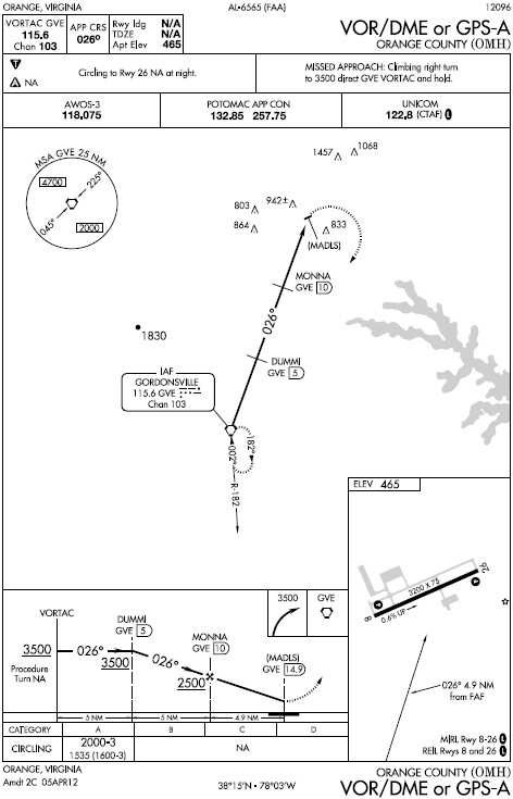
The initial plan was to run the VOR RWY 33 approach into RMN, which has a missed approach that sets up for a convenient transition to the ILS RWY 33 approach.  From there, we'd transition to the ILS RWY 3 at Charlottesville (CHO), which has a missed approach that sets us up for the VOR/DME-A at Orange (OMH).  Lastly, instead of flying the missed after OMH, we would proceed direct to Casanova (CSN) to fly the LOC/DME RWY 15 at Warrenton-Fauquier (HWY), and then take the missed back to CSN to pick up the VOR-A to CJR.  That all looks good on paper, or perhaps on your screen, but life thought it looked a little too good.

RMN VOR RWY 33
After departing CJR, we headed towards BRV to pick up the VOR RWY 33 approach at RMN.  I called Potomac TRACON to let them know where we were and what we were doing, just so they knew.  Mike flew the approach pretty well while I made sure to keep us out of the SFRA and away from traffic.  Everything looked good with the first approach, so we went missed to continue with the ILS RWY 33 approach, which has a really cool arc to it.  Unfortunately, while attempting to transition from the VOR radial outbound, onto the Localizer beam (LOC) inbound, we figured out that the instrument landing system (ILS) was out of service.  Since we were in the middle of an approach, neither of us really had the free brain power to make the connection between the ILS being out and the storm last night.  Mike tracked back to BRV to shoot another VOR approach so that we didn't waste the time.
RMN ILS RWY 33

After the second VOR approach into RMN, we went direct to CHO.  I called Potomac back to update them on our next plans, where I was then told he thought CHO's ILS was also out of service.  We thought to try Shenandoah (SHD), but started to wonder if that would be out because of the power outages, too.  We tossed around a few more ideas, but we were also getting hungry, slightly irritated at the hand we were dealt (no notices to airmen - NOTAMs - were issued for the outages), and we figured it was a good time to get some fuel, too.  In the end, we decided to set down at CHO.

On the way in, Potomac told us a few times that the automatic terminal information service (ATIS - broadcasts the weather information and continuously) was out, though it seemed to be just fine when I tuned it in a few minutes prior to calling them.  In any case, the controller passed the weather to us and sent us over to tower.

As we got closer, a MedFlight helicopter called tower up to report they were proceeding to a crash on Route 29.  Tower called our flight out as traffic to the chopper, but also threw in a quick remark that someone was already on scene.  I'll let you draw your own conclusions as to what the controller was trying to say, as the accident was right under where we were at that point.  I couldn't spot it and Mike was still under the hood to log more instrument time, so the controller advised us to turn south to avoid a conflict.  When we were out of the way, he cleared us to land so Mike took the hood off and set us down.

The Landmark crew set us up with the car and we set off toward Timberwood in hopes they had power, AC (did I mention it was really hot today?), and food.  While they had power, they unfortunately couldn't hold up the full menu, so we had some bar food.  I have to give them credit, as the bar food was pretty good, but I was disappointed I couldn't have a burger.  Back at CHO, Mike paid the fuel tab and we set back off for some more approaches.

OMH VOR-A
Back up in the air, we went over the ridge to Gordonsville (GVE) to shoot the VOR-A into OMH.  I called Potomac to let them know what we were doing.  The controller advised me that there were jumpers (skydivers) that were about to be released, and that I should call on the airport's frequency to coordinate with the pilot of their plane.  We coordinated, Mike held mid-approach for a lap, and then we continued inbound.  After overflying the field, we went towards CSN to fly more VOR approaches into HWY and a final approach into CJR.

HWY VOR RWY 15
The last controller we spoke to seemed to be in no mood to handle VFR traffic at all, so we ended up just flying the last three approaches on our own.  Between the first and second approaches to HWY, an aircraft had departed to remain in the traffic pattern.  I had to coordinate with him because what we were doing was very non-standard when compared to the very standard traffic pattern (if you look at the approach plate, we were approaching the field from an odd angle).  Since it was out of the ordinary and I wanted to make sure the guy knew exactly what we were doing, I got pretty explicit with my radio calls, which someone listening in on the frequency made a quick joke about.  After breaking off on the approach, Mike shot the last VOR approach into CJR, landed, taxied off, and shut down.


After I packed my stuff back up, I jumped back in the car and headed home while Mike took the plane back down to Richmond.  He's current again, I got some PIC time for being a safety pilot, and in the process we had a pretty good adventure of it.

Hours:
Pilot in Command Cross Country (PIC XC): 0.0 - 61.4 (of 50)
Actual/Simulated Instrument (Act/Sim): 0.0 - 6.6 (of 40)

07 June 2012

A Stormy First

N5294W - C172R - 1.7 hours

Earlier this week, Ashley asked if I wanted to go flying soon.  Of course, I'm always up for a flight and we both had time tonight, so I set us up with a plane for some flight maneuvers and perhaps an approach.  Her friend Greg also joined us to get a feel for flying the smaller stuff.  As far as flights in small planes go, this would be his first.  Unfortunately, throughout the week, the forecast had a decent chance of storms in the evening.  Leaving work, I could definitely see some convection that could get in the way, but summer storms are spotty and I know there are a good number of airports locally should we need to get down quickly.


While Ashley and Greg were caught in traffic, I got the plane all set up, and then relaxed in the shade under the wing for a few minutes.  Once they got there, Ashley ran through her own checks of things, explaining them to Greg.


I-66 below and 522 in the distance
After we all got situated, we departed to the west so that we could fly around the practice area (out by Winchester, VA).  On the way out, I took advantage of the fact that there was another pilot on board and got some hood time until we got out there.  Once there, Ashley took over to get some time at the controls to brush up on turns around a point and s-turns.  After a few attempts, hindered by the wind of a storm a few miles to the northeast of us, I was given the controls again for some hood work.  Ashley called out directions and I followed them to the best of my ability.


Of course, even though I checked to make sure the camera started the recording, it apparently died before I plugged it in after starting the plane, so I caught the few moments up to starting the engine and that was it.  The hood work, rainbow and lightning all went unrecorded.  Unfortunately, all of these issues were brought on by myself.  I never charged it after using it last, figuring I had enough time left to run it until I had a chance to plug it in.  Oh well.  Greg caught the rainbow with the still camera, so all wasn't lost.


In the end, Ashley directed me closer and closer to Winchester (OKV), where she could practice a few landings.  Since it had just rained and the runway was recently grooved, it was actually pretty cool looking.  The last few feet on either side didn't have grooves, so the rain made that part shiny, while the middle appeared perfectly dry.  After a couple trips around the pattern, I was handed the controls again and took us north towards the Martinsburg VOR (MRB).  Even though I didn't have my charts, my ForeFlight trial had expired, and I didn't want to look the chart up on my phone, I was still able to fly the approach by pulling it up in the KLN-94 GPS.  As opposed to the last logged approach, this one was a lot better.  We'll see how it looks next time.

I'm still trying to get over the fact that I need the same amount of time that it took to get my private pilot license under the hood for my instrument rating.  At least this flight took a full hour out of that total.

Hours:
Pilot in Command Cross Country (PIC XC): 0.0 - 56.3 (of 50)
Actual/Simulated Instrument (Act/Sim): 1.0 - 6.6 (of 40)

06 April 2012

A New Checklist Item

N172DR - C172R - 1.6 hours

First, I must point out why the title is what it is:
For the second time I've made a mistake with the video camera that has cost me some valuable footage.  Today, I somehow managed to turn the camera off instead of on, so I captured absolutely nothing today.  I missed two approaches, a whole bunch of pattern work, and a few other cool things that I guess I'll just try to convey via text.  The new checklist item, however, is "camera on and recording."

I only think it's recording right now

Camera issues and related frustration aside, it was actually an awesome flight.

My friend Ashley asked me yesterday if I would like to go flying sometime soon, and after telling her when I had time, she said "tomorrow?"  You all know I'm not one to turn down a flight, especially when it's with a fellow pilot I can split time with.  She's been wanting to find a pattern to get a few landings in for a while, so I began flipping between the hassle of staying here (JYO) or going to Winchester (OKV).

On the drive out, I'd been thinking more of flying out to OKV for a relatively empty pattern and not having to worry about special procedures.  When I got to the airport, I had time to kill, so I sat down and continued plotting.  That plotting included throwing in an instrument approach so I could log some more simulated instrument time and chip away at the rest of the 35 hours I still had left, so I bought a current copy of the Virginia and Maryland approach charts.

I settled on the OKV idea, and the Instrument Landing System (ILS) approach to Runway 32 at Winchester.  It was really convenient because it was in line with our route to the airport, and it put us out at an airport where we could run laps around the traffic pattern undisturbed.  On the way out I called up Potomac TRACON, who accommodated the request via radar vectors.  After a few heading changes, I was cleared direct to CLADD to shoot the approach.  Nearing CLADD it seemed like the localizer (the part of the ILS that guides me laterally) was reverse sensing (it was showing me right of course, when I was left), but it seemed more normal as I got to CLADD and continued inbound.  Ashley called out altitudes and watched for traffic while I had the horse blinders on, attempting to follow radio beams to the runway.  For one of my first times flying an instrument approach, it wasn't bad.  I was tracking the localizer well, but there was a mix up with the frequency set in the second nav radio, so I wasn't able to pick up the necessary cross radials off of Linden to determine my steps down in altitude before intercepting the glideslope (the part of the ILS that guides me vertically).  That put me above the glideslope, but after checking how far I was from CLADD on the GPS, I found that I was near the point that I should be following the glideslope and descended to capture it and follow it all down to the runway.  I took the blinders off just above the minimum descent altitude (MDA) for the approach and landed with a little bit of a gusty wind from the north.

After landing, we taxied back to Runway 32 to do some pattern work.  Ashley took the first lap around and opted for a go-around after the wind tossed us around some on short final.  On climbout, I was handed the controls again to give her a break from fighting the wind for a lap.  My first trip around the pattern wasn't too bad, but the wind did distort it slightly.  The strong wind from the north meant there was a decent crosswind, but it also meant that we had to turn to base and final closer in to keep the same descent angles.  If you're not used to adjusting your pattern for wind, it can definitely throw you off.

Ashley took over again for a few more trips around the pattern with better results.  For not having flown in a while, the landings were on point, and they only got better with each pass.  I made a few more landings of my own, and I remember thinking that I was glad I had the camera to record some of them.  Right... Taxiing back for the last departure, I pulled out the approach plates again to get set up for another instrument approach heading back into JYO.

After departing OKV, I turned north towards Martinsburg (MRB) to pick up the VOR (navigation radio) there as it's the initial approach fix (IAF) for the ILS Runway 17 approach into JYO.  Potomac again got me situated on the approach, and provided traffic advisories.  Over MRB, I was switched from 120.45 (MANNE) to 126.1 (MULRR), and then over to ASPER (125.05) as I got closer to getting established on the localizer.  The controller saw that I was established on the approach and told me to switch over to JYO's CTAF so that I could let them know what I was doing.  He also, however, told me to remain outside of the Class B airspace, which annoyed me to a certain degree.  I understand the controller had a job to do that was a lot more important than VFR practice approaches, but it put me in a tough spot not knowing specifically that the approach in itself would keep me out of the Bravo airspace.  I'll readily admit that I didn't cross-reference the approach chart with a sectional to see if the approach remained clear of the airspace, but finding that information out is not as simple as you'd think.

The approach chart clearly shows the SFRA, but nowhere does it show the overlying Bravo shelves (it wouldn't need to if you're IFR, anyway).  The Sectional Chart also clearly shows the SFRA and the Bravo shelves, but not the instrument approach, or the fixes on the approach.  You'd think the FAA would design approaches with things like that in mind, but that's not the case.  There was a big issue a few years ago where one of the missed approach procedures at Frederick (FDK) placed you inside of the ADIZ (precursor to the SFRA).  If you were flying VFR practice approaches and you ended up flying the missed approach, you would bust the airspace.  Despite this, there was very little understanding from the FAA.  The AOPA fought hard against it so the FAA, as a result, began depicting the ADIZ (and later the SFRA) on the charts for situational awareness, but the stance remains: bust the airspace, and we'll bust you.

In any case, my distraction with trying to remain under the Bravo, while also flying the approach took its toll and I ended up right of course.  That all worked out in the end, though, as that put me in the right spot to enter the traffic pattern for Runway 35.  As we arrived in the traffic pattern, though, a helicopter based at JYO called inbound for a non-standard entry into the pattern.  Luckily, we spotted it pretty far out, and they called us in sight soon after.  Even so, it was unnerving turning towards it on base, and even more so knowing it was also going to approach over the taxiway parallel to me.  When I turned final, I attempted to just lock everything else out of my head except landing, and because of that, I pulled off one of my best landings ever, celebrating in my mind that I just caught it on camera.  Again...right... I even managed to have the nose up (a rarity for me, as you know) and the stall warning as I touched.

As I taxied off, I got buzzed by the helicopter, which I wasn't so pleased with, but it's not like it was too close for comfort.  It's just startling to have a large bright yellow thing pass just ahead of and above you.  After parking, we put the plane back in its spot and set off for a much needed dinner.

For those of you who fly out of JYO and are wondering what I found out about the ILS Runway 17 approach, it does actually remain under the Bravo.  I made the chart by superimposing the approach chart on top of a sectional and copying the Class B lines over.  Obviously, it's for reference only, and don't come busting down my door if the FAA comes busting down yours.  If you're still unsure, you can go to SkyVector.com and enter the approach fixes to see where they're depicted on the sectional and you can check the altitudes on your own.


Let's see if I can actually remember to turn the camera on next time.


Hours:
Pilot in Command Cross Country (PIC XC): 0 - 50.4 (of 50)
Actual/Simulated Instrument (Act/Sim): 0.7 - 5.6 (of 40)