12 July 2012

Another Flight Out West

N96178 - C172P - 2.0 hours

I was supposed to go flying on the 4th, but for various reasons that didn't end up happening.  Since then, it's been a little rough between my personal life and work, so I figured I'd take myself flying to clear my head.  Before I go any further, I just want to point out that I did consciously wait until a point in the week that my head was clear enough to actually fly safely.  I just wanted to put that out there before someone decided to call me out on the S in the IMSAFE checklist.

Ground life aside, I figured I'd head out west to try a new destination on my own.  The flight back would be at night, too, which would count towards hours I'll need in my next rating (commercial rating: 61.129(a)(4)(ii) Solo VFR Night).  I debated a few destinations, to include Altoona (AOO), Somerset County (2G9) and Garrett County (2G4).  I ended up settling on 2G4 primarily because one of my ideas for my long IR XC includes approaches at AOO and 2G9, so I figured I might as well go somewhere I won't go on that flight.  My friend Phil flew out there a while ago and he seemed to enjoy the flight, which factored into the decision.  Finally, of all of the airports I've flown in and out of, it would be the highest in terms of altitude above sea level, at 2933'.  Before tonight, that spot was held by Blacksburg (BCB) at 2132'.

CBE In the distance
The flight out was slightly hazy looking west, but as the daylight waned, the haze became less of a problem.  I passed just north of Winchester (OKV) and south of Cumberland Regional (CBE), where I flew back in December.  The original track would've had me a lot further south of CBE, but I changed my track to go direct to the Grantsville (GRV) VOR so I could fly the VOR RWY 27 approach into 2G4.  I was able to spot GRV in the middle of a field as I flew overhead, which made timing my turn for the approach pretty easy.  Obviously, the practice approach was simply to get used to working the radios and flying approaches on my own.  Not having a safety pilot to look out for me, I couldn't wear the blinders and log the approach, but I still think it was worth it to get used to the idea of flying approaches.  If nothing else, I was able to see what the approach looks like out the window.

I reported my position inbound to land on Runway 9 as soon as I passed over GRV, and made the standard calls from then on.  Luckily, the approach off of GRV puts you on the downwind for Runway 9 if you fly it long enough.  The wind was pretty light, but 2G4 is around a lot of changes in terrain.  It's perched near the top of the hill, so there are all kinds of weird wind issues as the wind carries up and downhill.  Adding to that, the crest of the hill is slightly north of the field and is 20-40 feet higher, which changes that dynamic as well.  All of that together makes even light wind somewhat of a battle all the way down final and into ground effect.  I pulled off the runway after landing and taxied back to kill some time to let it get darker.  When I got back to the end of the runway, I noticed a ski resort south of the field.  Google Maps says that it's Wisp (it's just out of the frame to the left in the picture), so if anyone needs a flight this winter, let me know.

On the way home, I listened to Cleveland and Washington Center sequence traffic into Dulles, National and BWI to pass the time on an otherwise quiet flight home.  As I got closer to OKV, I circled around the city in order to log a little more time at night.  In the end, I came out with 1.1 hours more hours of solo VFR night.  Unfortunately, my long time buddy N96178 has a fully front lit panel, and not the nice back lit panel of the newer R models I've been flying.  For those of you who don't know what I'm talking about, turn down the dash lights in your car, shine a red flashlight on the speedometer, and try to drive like that.  It made for an interesting approach, since I couldn't see the airspeed indicator as well as I would've liked, but the landing wasn't half bad.  You know the rest.

Proof that sunsets from the air are thousands of times better than on the ground
Hours:
Pilot in Command Cross Country (PIC XC): 2.0 - 63.4 (of 50)
Actual/Simulated Instrument (Act/Sim): 0.0 - 6.6 (of 40)

30 June 2012

Who Knew ILSs Needed Power?

N49134 - C152 - 2.6 hours

Since I've been trying to get the long IR XC out of the way, I've been bugging my friend Mike to get current again so that he could ride right seat for the flight so I didn't have to pay an instructor (certified flight instructor - CFI) to sit there.  Of course, it wasn't until later that I re-read the regs and found out that the flight requires a CFI, and not just an instrument rated safety pilot.  In any case, a friend needed a safety pilot to get instrument current again, and I was definitely up for that.

Sherriff SUV powering a light on 29
Mike lives down in Richmond, so we decided to meet up in Culpeper (CJR).  That plan meant I didn't have to drive too far, and he didn't have to use extra time on the plane to get all the way to Leesburg (JYO).  The drive down to CJR required a trip down Route 29, which is by far my least favorite drive in the world because of the quantity and poor timing of the traffic lights.  On a stroke of unfortunate luck, the power was out for a good amount of Virginia, so most of those lights were out and very few people were on the road.  I made it down in record time, but Mike got hung up because the airport he was flying out of didn't have power to pump fuel.  Luckily, a nearby field did, so he stopped there on the way up.

I killed some time with a run into the town of Culpeper, and then sat in the CJR terminal for a while listening to the local pilots tell their stories of how bad the storm affected them last night.  After sitting around for a while and developing a plan of attack where one approach dumped onto, or close to where another picked up, Mike arrived and we set off towards Stafford (RMN).

The Plan
The initial plan was to run the VOR RWY 33 approach into RMN, which has a missed approach that sets up for a convenient transition to the ILS RWY 33 approach.  From there, we'd transition to the ILS RWY 3 at Charlottesville (CHO), which has a missed approach that sets us up for the VOR/DME-A at Orange (OMH).  Lastly, instead of flying the missed after OMH, we would proceed direct to Casanova (CSN) to fly the LOC/DME RWY 15 at Warrenton-Fauquier (HWY), and then take the missed back to CSN to pick up the VOR-A to CJR.  That all looks good on paper, or perhaps on your screen, but life thought it looked a little too good.

RMN VOR RWY 33
After departing CJR, we headed towards BRV to pick up the VOR RWY 33 approach at RMN.  I called Potomac TRACON to let them know where we were and what we were doing, just so they knew.  Mike flew the approach pretty well while I made sure to keep us out of the SFRA and away from traffic.  Everything looked good with the first approach, so we went missed to continue with the ILS RWY 33 approach, which has a really cool arc to it.  Unfortunately, while attempting to transition from the VOR radial outbound, onto the Localizer beam (LOC) inbound, we figured out that the instrument landing system (ILS) was out of service.  Since we were in the middle of an approach, neither of us really had the free brain power to make the connection between the ILS being out and the storm last night.  Mike tracked back to BRV to shoot another VOR approach so that we didn't waste the time.
RMN ILS RWY 33

After the second VOR approach into RMN, we went direct to CHO.  I called Potomac back to update them on our next plans, where I was then told he thought CHO's ILS was also out of service.  We thought to try Shenandoah (SHD), but started to wonder if that would be out because of the power outages, too.  We tossed around a few more ideas, but we were also getting hungry, slightly irritated at the hand we were dealt (no notices to airmen - NOTAMs - were issued for the outages), and we figured it was a good time to get some fuel, too.  In the end, we decided to set down at CHO.

On the way in, Potomac told us a few times that the automatic terminal information service (ATIS - broadcasts the weather information and continuously) was out, though it seemed to be just fine when I tuned it in a few minutes prior to calling them.  In any case, the controller passed the weather to us and sent us over to tower.

As we got closer, a MedFlight helicopter called tower up to report they were proceeding to a crash on Route 29.  Tower called our flight out as traffic to the chopper, but also threw in a quick remark that someone was already on scene.  I'll let you draw your own conclusions as to what the controller was trying to say, as the accident was right under where we were at that point.  I couldn't spot it and Mike was still under the hood to log more instrument time, so the controller advised us to turn south to avoid a conflict.  When we were out of the way, he cleared us to land so Mike took the hood off and set us down.

The Landmark crew set us up with the car and we set off toward Timberwood in hopes they had power, AC (did I mention it was really hot today?), and food.  While they had power, they unfortunately couldn't hold up the full menu, so we had some bar food.  I have to give them credit, as the bar food was pretty good, but I was disappointed I couldn't have a burger.  Back at CHO, Mike paid the fuel tab and we set back off for some more approaches.

OMH VOR-A
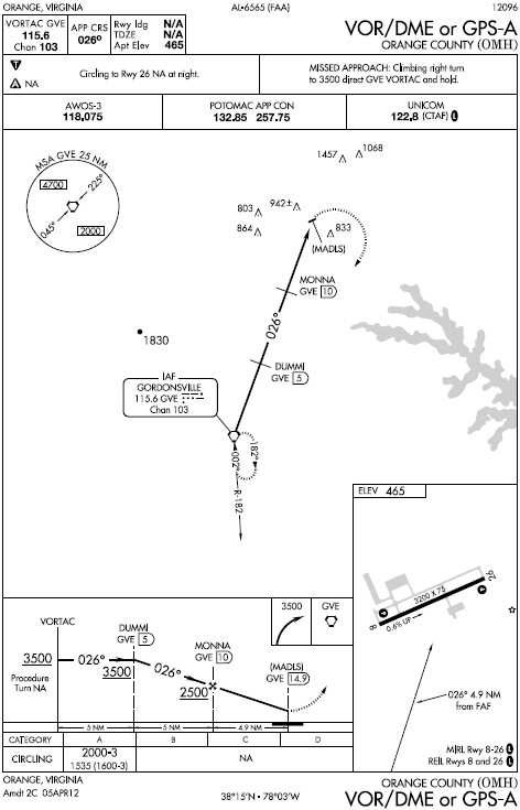
Back up in the air, we went over the ridge to Gordonsville (GVE) to shoot the VOR-A into OMH.  I called Potomac to let them know what we were doing.  The controller advised me that there were jumpers (skydivers) that were about to be released, and that I should call on the airport's frequency to coordinate with the pilot of their plane.  We coordinated, Mike held mid-approach for a lap, and then we continued inbound.  After overflying the field, we went towards CSN to fly more VOR approaches into HWY and a final approach into CJR.

HWY VOR RWY 15
The last controller we spoke to seemed to be in no mood to handle VFR traffic at all, so we ended up just flying the last three approaches on our own.  Between the first and second approaches to HWY, an aircraft had departed to remain in the traffic pattern.  I had to coordinate with him because what we were doing was very non-standard when compared to the very standard traffic pattern (if you look at the approach plate, we were approaching the field from an odd angle).  Since it was out of the ordinary and I wanted to make sure the guy knew exactly what we were doing, I got pretty explicit with my radio calls, which someone listening in on the frequency made a quick joke about.  After breaking off on the approach, Mike shot the last VOR approach into CJR, landed, taxied off, and shut down.


After I packed my stuff back up, I jumped back in the car and headed home while Mike took the plane back down to Richmond.  He's current again, I got some PIC time for being a safety pilot, and in the process we had a pretty good adventure of it.

Hours:
Pilot in Command Cross Country (PIC XC): 0.0 - 61.4 (of 50)
Actual/Simulated Instrument (Act/Sim): 0.0 - 6.6 (of 40)

16 June 2012

Visiting an Old Friend

N96178 - C172P - 3.2 hours

My cousin got engaged about a month ago, which is, of course, a reason for celebration.  Because my cousin's now fiancĂ©e grew up in Roanoke, and that's where they currently live, said celebration would be down there.  I decided to save myself the hassle of driving and fly down.  Excuses, right?

Sitting right seat was my buddy Aaron (from one of the several CHO flights), who was along to enjoy the flight and share some time at the controls.

In order to cut costs slightly, I booked a C172P, which is an older model than I normally fly.  As an interesting aside (okay, it might be slightly more interesting to me than it would be to you), the only C172P left at Av-Ed (JYO) is N96178, which is the plane I soloed in 9 years ago.  Since then, it's gotten a few avionics upgrades, to include a Garmin 530.  If you're wondering where the post's title came from, it's an allusion to the plane.

EMB-120 that arrived during the delay
The day didn't start off too well as Landmark Aviation JYO had apparently forgotten to order fuel prior to today, so they were out by this morning.  Because of that, the local planes were having to fuel up in Winchester (OKV), which is some 20-30 minutes away by air.  In the end, we got the plane an hour after we were supposed to depart with it.  Despite the delay, I've read enough horror stories in past issues of AOPA's magazines and other books to remind myself to always be thorough, even when in a rush.  After my normal preflight, we jumped in and took to the sky.


Of course, the clouds had dropped slightly lower, which cut us off from my over-the-mountain direct plan, so we had to fly south past Charlottesville (CHO), follow the I-64 mountain pass, and then continue down I-81 to Roanoke (ROA).  This, of course, added more time.  I can't really argue, though.  Aaron is working towards his private pilot license (PPL), so I let him take the controls for a good portion of the flight.  We definitely got to see some cool scenery, though.  The weather being nicer, people were all over the rivers and lakes, too.

After calling Roanoke Approach up, they vectored me inbound for an approach on Runway 6.  If you watch the video, you an see that the flight path follows I-81 for a while (prior to and after ROA's vectors).  From there, we flew west of Tinker Mountain (the twin-peaked mountain in the picture at left), then over Carvins Cove Reservoir, and onto the downwind.  Approach turned me over to tower, who cleared me to land midfield on the downwind.  In an effort to get in a little quicker, I turned base way too close to the runway and ended up having to slip to kill altitude all the way down final.  The approach was salvaged, I landed pretty well all considering, and made my intended taxiway, so all wasn't lost.  Tower sent me to ground, ground got me pointed towards Landmark ROA, and after parking we set off towards family and food.


The way back also had clouds in the way of my intended more direct route, but this time larger breaks allowed a slightly more direct route than the way down.  After departing ROA, I asked for flight following and in the 1.6 hours that followed we had a few traffic calls, mostly as we got closer to Dulles (IAD).  Nothing too incredibly interesting happened otherwise.  Sorry for the relatively boring narrative for the way back, but sometimes, things are just simple and that's all you can say.

Hours:
Pilot in Command Cross Country (PIC XC): 3.2 - 61.4 (of 50)
Actual/Simulated Instrument (Act/Sim): 0.0 - 6.6 (of 40)

08 June 2012

Comfort Food in Charlottesville

N1090V - C172S - 1.9 hours

My friend Christina helped kick this blog off with Let the Cross Country Begin, but she hasn't flown since for a number of reasons.  Earlier in the week, though, she asked if she could bring a friend along for a trip down to Charlottesville (CHO).  Part of it would be something to do while their respective guys were out for their own entertainment that night, and the rest of it was to introduce her friend Brittany to flying.  This flight would make two introductions to small planes this week for me, and it was really a first time in a plane of any size for her.

As life is always interesting for me, we showed up to the airport with my request of two headsets sitting in the lock box, but no keys or book for N172DR.  Luckily, there were a few planes that would be back slightly after we'd intended to leave, so I we waited until one got back and just took that one.  The one that came back first, however, was of course one of the G1000 172s that I love so much.  As you may remember, I've come to terms with them because of the cool technology (and it could've saved my life), but for my average flying I still find it unnecessary.  In any case that's what we had, and I would, of course, live it up.  I had one of the nicest planes in the fleet.  Why not?

Just to ease any nervousness that might be building closer to departure, I made sure to explain what I was doing as I walked around, taxied out, checked the engine, and put the plane up in the air.  After departing, Christina asked if we'd be able to see Upperville (2VG2) as we flew out, so I adjusted course to overfly it.  Naturally, comments were made about RESTRICTED being written all over the runway.

The sky was remarkably clear, so I pointed out a few planes on the western arrivals into Dulles, aided by the G1000 traffic display.  They were all RJs of some sort, but Christina and Brittany were both able to spot one of them as it passed over.  The delay earlier had also put us closer to sunset, so we got to watch that on the way down.  Sunsets are so much better up in the air, as you can see evidenced to the right.

On the way down, I called Potomac Approach to get flight following, which makes the whole flight into CHO a little easier.  As usual, I talked to ASPER, MANNE and CHOWE before getting passed on to tower.  The wind at CHO was from the south, so I was instructed to make a straight in approach to Runway 21.  The straight in approach really makes the flight all too easy, but I'm not complaining.  The landing is below.  As usual, I'm pretty proud of myself for landing with enough nose up attitude to get the stall warning to go off (that's what that annoying sound is right before I touch down, if you didn't know already), since that's not a norm for me.  The large plane on the ramp is a C130.  I have no idea why it was there.


[Video was here until Contour closed down for a bit, and the video was lost.]


For the first time ever, I walked in and Keya wasn't there, but the rest of the ramp crew was.  By now, you know the story.  We stole the car, drove to Timberwood, and a Clint Eastwood was eaten.  I also asked the waitress if the picture my friend Melissa and I had drawn last time we were there was up somewhere, and it apparently made an appearance for a while at the server station.  I'll admit to being a little proud of that one, too.

After dinner, we headed back to the airport, paid for fuel, and set back off towards Leesburg (JYO).  By that time, it was dark, but we were off in no time, after a quick wait at the end of the runway for a landing ERJ for American Eagle.  On the way back, Christina made a comment about how it would be cool to land at Dulles (IAD), which I took and ran with.  I had checked the ATIS a few minutes earlier and they were in north ops, so it wouldn't have been out of anyone's way, necessarily.  I don't have the LiveATC recordings, but it went something like this:

N1090V: "Hey Potomac, Cessna 1090V, how busy are you guys right now?"
CHOWE: "You're only in my airspace for another few miles.  What do you want?"
N1090V: "I'm just checking to see if I could get a touch and go at Dulles."
CHOWE: "Cessna 1090V, contact Potomac on 126.65.  I've passed your request on to him."
N1090V: "Awesome.  Thanks.  Potomac on 126.65, Cessna 1090V."
N1090V: "Potomac, Cessna 1090V, 5500."
TILLY: "Cessna 1090V, Potomac, roger.  Confirm your request for a...touch and go at Dulles?"
N1090V: "Affirm, Cessna 1090V.  We can take 1L to stay out of the way."
TILLY: "1L is closed, but you might be able to do 1C.  I've passed it on to a Sup.  Can we even do that?  We'll let you know."
TILLY: "Cessna 1090V, Dulles tower said they'd take you on 1C.  Expect visual 1C, fly heading 060, descend and maintain 5000."
N1090V: "Expect visual 1C, heading 060, descend and maintain 5000, Cessna 1090V.
TILLY: "Cessna 1090V, fly heading 090, descend and maintain 3000.  I'm sequencing you number 3 behind a 757 and an ERJ."
N0190V: "Heading 090 and down to 3000, Cessna 1090V."

After unkeying the mic, I laughed about being behind one of the most dangerous aircraft to possibly be behind, in terms of wake turbulence.  At least I had a buffer with the ERJ between me and it.

TILLY: "Cessna 1090V, traffic 9 oclock, 3 miles, eastbound turning to final, ERJ, 3000.  Report traffic in sight.
N0190V: "Traffic in sight, Cessna 1090V."
TILLY: "Cessna 1090V, follow that traffic, cleared visual approach Runway 1C."

As I got closer, I heard the controller ask a Southwest 737 if he wanted Runway 1R or 1C.  The pilot took 1C so I kept my speed up on the way in, which you can hear in the video.  You can also hear a few remarks by me, along with Christina and Brittany.  One of them is me explaining why the G1000 kept yelling TRAFFIC, TRAFFIC (plane in the Runway 30 hold block left had its transponder on - comment at 01:45), and the other one is me confirming that, yes, we are, in fact, a big deal (comment at 2:10).  For those familiar with the area, the video starts over Westfield High School.


[Video was here until Contour closed down for a bit, and the video was lost.]


The rest of the flight was remarkably short.  The tower controller had me fly heading 330 until I had JYO in sight, and even so, he kept me on the frequency until pretty close to turning final.  At that point, I was turned over to JYO's frequency.  You know the story from there.  The FlightAware track is below.  For the record, I'm not a fan of the new high contrast lettering, and it's clearly the end of the world.  The circles around JYO are from the previous flight, which was all pattern work.


Hours:
Pilot in Command Cross Country (PIC XC): 1.9 - 58.2 (of 50)
Actual/Simulated Instrument (Act/Sim): 0.0 - 6.6 (of 40)

07 June 2012

A Stormy First

N5294W - C172R - 1.7 hours

Earlier this week, Ashley asked if I wanted to go flying soon.  Of course, I'm always up for a flight and we both had time tonight, so I set us up with a plane for some flight maneuvers and perhaps an approach.  Her friend Greg also joined us to get a feel for flying the smaller stuff.  As far as flights in small planes go, this would be his first.  Unfortunately, throughout the week, the forecast had a decent chance of storms in the evening.  Leaving work, I could definitely see some convection that could get in the way, but summer storms are spotty and I know there are a good number of airports locally should we need to get down quickly.


While Ashley and Greg were caught in traffic, I got the plane all set up, and then relaxed in the shade under the wing for a few minutes.  Once they got there, Ashley ran through her own checks of things, explaining them to Greg.


I-66 below and 522 in the distance
After we all got situated, we departed to the west so that we could fly around the practice area (out by Winchester, VA).  On the way out, I took advantage of the fact that there was another pilot on board and got some hood time until we got out there.  Once there, Ashley took over to get some time at the controls to brush up on turns around a point and s-turns.  After a few attempts, hindered by the wind of a storm a few miles to the northeast of us, I was given the controls again for some hood work.  Ashley called out directions and I followed them to the best of my ability.


Of course, even though I checked to make sure the camera started the recording, it apparently died before I plugged it in after starting the plane, so I caught the few moments up to starting the engine and that was it.  The hood work, rainbow and lightning all went unrecorded.  Unfortunately, all of these issues were brought on by myself.  I never charged it after using it last, figuring I had enough time left to run it until I had a chance to plug it in.  Oh well.  Greg caught the rainbow with the still camera, so all wasn't lost.


In the end, Ashley directed me closer and closer to Winchester (OKV), where she could practice a few landings.  Since it had just rained and the runway was recently grooved, it was actually pretty cool looking.  The last few feet on either side didn't have grooves, so the rain made that part shiny, while the middle appeared perfectly dry.  After a couple trips around the pattern, I was handed the controls again and took us north towards the Martinsburg VOR (MRB).  Even though I didn't have my charts, my ForeFlight trial had expired, and I didn't want to look the chart up on my phone, I was still able to fly the approach by pulling it up in the KLN-94 GPS.  As opposed to the last logged approach, this one was a lot better.  We'll see how it looks next time.

I'm still trying to get over the fact that I need the same amount of time that it took to get my private pilot license under the hood for my instrument rating.  At least this flight took a full hour out of that total.

Hours:
Pilot in Command Cross Country (PIC XC): 0.0 - 56.3 (of 50)
Actual/Simulated Instrument (Act/Sim): 1.0 - 6.6 (of 40)

25 May 2012

Solo to the West

N5294W - C172R - 1.6 hours

At first, my old college roommate and I were supposed to head up to State College (UNV) on Wednesday so I could head out to a new place and get some hood time.  That ended up getting scrapped because the weather was less than ideal.  Then, on Friday, I was supposed to head out with Ashley on a flight similar to our flight a month ago, but her job got in the way.  Life and weather both happen, so you work the hand you were dealt.  The tease of flying got under my skin though, so I was going flying with or without someone else in the right seat.

Similar to my last flight, I had a couple destinations in mind.  To the west, I picked out Grant County (W99) because it's a quick trip and it's surrounded by mountains.  To the east, I picked out Bay Bridge (W29) because it's through the VFR Corridor, which is a challenge, and it's right out on the Chesapeake Bay.  In the end I picked W99 because I really didn't want to bother with a flight plan, or the SFRA.

Note the odd trend of laziness when I don't have people to fly with.  Oh well.  As long as I'm doing what I need to do to stay safe, I'm allowed to pick destinations based on how little effort they require if it's only for myself.

What haze?
I had left my sun glasses in the plane last flight.  Thanks to the staff they were sitting in the book when I grabbed it out of the lock box.  Nothing at all interesting happened on the way out.  The weather, however, wasn't the most optimal, with a little haze when facing the sun.  After passing north of Upperville (2VG2), I called Potomac Approach for flight following, which continued with Washington Center all the way out to W99.


Similar to Bedford County (HMZ), W99 is buried in the mountains.  Unlike HMZ though, it doesn't have any mountains on short final.  According to the Airport/Facility Directory (A/FD), there's a fly-in campground on the field somewhere, but I didn't see it.  Sounds like it could be a fun outing if I ever figure it out.  After taxiing back, I made a short and soft field takeoff to keep it interesting, as usual.

On the way back, I let Washington Center deal with its business without having to look after me since the frequency sounded busier.  I monitored the frequency all the way back to Strasburg to listen in for traffic, however.  Strasburg is where the grandparents live, so as I passed over, I descended to about 1000' above ground level (AGL), circled once, and then climbed back up and continued on to JYO.

Closer in to JYO, I set myself up for an approach to Runway 17, landed, taxied off and shut down.  Hopefully next time will be more exciting.  W99 is a cool airport, but it's less interesting to me when there's nobody to share it with.


Hours:
Pilot in Command Cross Country (PIC XC): 1.6 - 56.3 (of 50)
Actual/Simulated Instrument (Act/Sim): 0.0 - 5.6 (of 40)

17 May 2012

Some Solo Time

N172DR - C172R - 1.5 hours

Looking back at my logbook, I noticed that in the time between getting my license in 2007 and now, I have flown 55.1 hours.  Of that time, I've only flown 1.1 hours as what the FAA calls 'solo,' which is when a pilot flies as the sole occupant in the aircraft.  It's not a bad thing that I haven't flown more solo, it's just an interesting stat.  To me, it just means I've been sharing the experience with people.  Still, there's something to be said for putting yourself up in the air alone.  It's really peaceful.

Knowing that, in addition to the weather taunting me with its clear skies and calm wind, I caved and booked some time.  I didn't know where I'd go, and spent a few minutes at work plotting various places I could go, but still hadn't fully decided.  Once at the airport, I asked one of the instructors for his suggestion, but his suggestion involved a longer trip and a tower.  Despite my normal enjoyment in flying with ATC, today just seemed like a day to set out on my own.  In the end, I settled on Bedford County (HMZ).

Bedford County Airport is just north of the town of Bedford, Pennsylvania.  It's only 75nm from JYO, which makes it a shorter trip, but it's also an airport I haven't been to, out in the mountains.  For some reason, the challenges of airports around mountains have always drawn me to them.  That draw generally dies somewhat when I'm flying in the clouds (with a rated pilot, of course), but it's still fun provided you follow the approach correctly.

The preflight, taxi out and departure were all the normal boring stuff, with the exception of the Waco (a modern bi-plane) that came in.  On the way out, I ended up flying over my grandparents' old place outside of Purcellville again, and made my way towards MRB and then HMZ.  The flight was uneventful, and I talked to Washington Center (ZDC) for a few minutes until I began my descent into HMZ.

The approach into HMZ is somewhat of a challenge when landing to the northwest as there's a narrow pass to slip through that's not exactly in line with the runway.  It's not extreme or difficult, but it's definitely not the standard approach.  You can see it better in the video at the end of the post.


On the way back, I talked to ZDC again, along with Potomac Approach (both MULLR and ASPER), and requested the ILS 17 into JYO.  Since I was flying solo, I obviously didn't put on the hood or log it, but I thought it would be a good way to get familiar with the approach and working it all on my own.  I also got a chance to use ForeFlight on my iPad.  It was pretty cool for the plates, but I haven't actually bought it yet, so it was slightly limited (in addition to not having an external GPS receiver).

The controller working ASPER somehow managed and agreed to work me in on the approach despite being busy, which was awesome of her.  From there you know the rest.  It was definitely nice to get out there on my own.  Apparently, there's a requirement for the next rating I'll be going for (commercial), that requires some solo pilot in command (solo PIC) night flight, and I just knocked 0.8 of that out.


The video is in portrait because I never checked to see if I returned the camera's setting to landscape after a cross country drive I took a few weeks ago.  I'm beginning to think I need to add in several checklist items so I stop screwing up the videos of my flight.  At least I'm making sure to fly properly.

Hours:
Pilot in Command Cross Country (PIC XC): 1.5 - 54.7 (of 50)
Actual/Simulated Instrument (Act/Sim): 0.0 - 5.6 (of 40)